Space-Based LiDAR: Revolutionising the Environmental, Infrastructure and Agriculture Industries
Explore how NUVIEW is revolutionising the environmental, infrastructure and agriculture industries with space based LiDAR.
There are approximately 1.16 million kilometres of coastline globally. These environments hold immense resource, recreational and ecological value. Unfortunately, due to human impacts, changing sea levels and irregular storm patterns, coastal ecosystems are losing their natural resilience. Not only does this impact the stability of the natural environment, but also the health and safety of the people that live and work in coastal areas. Monitoring changes in erosion and shoreline characteristics is essential to inform coastal protection measures and preserve coastline resilience. LiDAR (light detection and ranging) has emerged as an innovative tool in terrain and elevation mapping not only for coastline management but other industries as well. Previously LiDAR data from planes and drones has primarily been used. Now, with space-based LiDAR, coverage has vastly improved. Below, we will explore 3 applications for Nuview’s revolutionary space-based LiDAR.
What is LiDAR?
LiDAR technology uses pulses of light to measure elevation and shapes. Because light travels at a constant known speed, LiDAR systems can accurately calculate the distance between the on-board light source and the collision point on the earth’s surface. As the satellite orbits, the series of light pulses and detected collisions build a precise 3-dimensional map of elevation and topography. LiDAR has proven to be useful due to the accuracy of the measurements and its ability to capture data day or night.

Credit: NUVIEW
LiDAR From Space
As of 2023, only 5% of earth has been mapped with LiDAR. Current methods using LiDAR data from vehicles, aeroplanes and drones are limited by distance and speed. Alternatively, space-based LiDAR provides a more efficient and comprehensive coverage. While in orbit, satellites with LiDAR can make continuous measurements on a global scale and accelerate the delivery of data. Additionally, space-based lidar removes operational and compliance costs often associated with terrestrial, drone, or aerial lidar. The goal of space-based LiDAR is to create a complete and accurate virtual representation of the earth to improve situational awareness.
Florida based NUVIEW, seeks to revolutionise the earth observation industry by building the first commercial LiDAR satellite constellation. This technology would allow for the entire land surface of the earth to be mapped, providing valuable information to environmental science, infrastructure, agriculture, forestry and many other industries. NUVIEW LiDAR will begin their first launch in 2024 and imagery will be commercially available on Arlula’s Geostack platform in 2025. The Arlula x NUVIEW partnership continues to revolutionise the earth observation industry and provides a new opportunity for industries to derive insights and power critical decisions.
LiDAR For:
Environment
Space-based LiDAR provides vital data to environmental industries. One application is in accurate habitat mapping. By providing a 3D representation of vegetation and landscape, it can significantly aid in conservation planning and biodiversity assessments. Detailed analysis of elevation data from repeated LiDAR captures provides a picture of erosion patterns and identifies wetland boundaries, thereby improving land management and restoration practices. When combined with additional behaviour data, space-based LiDAR imagery can enhance the mapping and planning of expansive biological corridors and habitat connectivity. Understanding how terrain influences wildlife movement will provide a complete picture for researchers and conservation efforts to map habitat connections and conserve vital landscapes. The detailed elevation, terrain maps and surface models from LiDAR satellites can be integrated with other geospatial databases such as GIS. These data points are foundational layers when it comes to mapping initiatives. These layers play a vital role in identifying hazard prone areas, such as low lying basins, ultimately, contributing to effective risk mitigation and disaster response.

LiDAR data of natural land depressions scattered throughout the Atlantic coastal plain of the United States. These are the Carolina Bays in North Carolina, USA. Captured by aerial lidar in December 2000.
Infrastructure
Precise LiDAR data provides critical information for efficient planning and maintenance of infrastructure. Accurate elevation mapping enables precise line of sight analysis. Resulting LiDAR maps provide a complete picture of any possible interference or obstructions when planning networks or addressing existing issues. With repeated image captures, vegetation encroachment can be identified through canopy cover and height values. One of the most advantageous applications of space-based LiDAR satellite imagery is the resulting high-resolution 3D models and maps of entire networks. These digital resources can easily be shared within a team enabling remote inspection, reducing the need for technicians or supervisors to complete a site visit. Space-based LiDAR data does not only enhance collaboration but also contributes to a thorough understanding of elevation to enable efficient and cost-effective infrastructure planning and development.
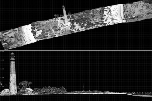
Aircraft LiDAR data collected by NOAA of Loggerhead Key Lighthouse, Dry Tortugas, Florida.
Agriculture
Improve precision agriculture with space-based LiDAR. High resolution 3-dimensional elevation maps provide insights into water flow patterns within fields to optimise crop and irrigation planning, ultimately enabling resource conservation. Generate accurate maps of vegetation canopy height and integrate with other data sets, such as Normalised Difference Vegetation Index, to assess vegetation health and improve production. Maintain a thorough understanding of soil types and erosion with precise LiDAR data to address erosion concerns and identify risks throughout the entire property. Accurate digital property maps made with space-based LiDAR data empower agriculture professionals to plan fields with precise measurements, effectively maintain property boundaries and optimise crop production from a central base.
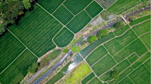
Credit: TomFisk
The utilisation of space-based LiDAR with NUVIEW’s innovative constellation, is revolutionising industries. Traditional mapping methods are impaired by time consuming visits, inaccurate information and significant cost implications. By offering detailed and precise elevation data, NUVIEW empowers the environment, infrastructure and agriculture industries. Available soon on Geostack, explore the potential of space-based LiDAR to power accurate and informed critical decisions.
More news

.png)

Let’s talk about how you run EO today
Most conversations start with understanding your current systems, workflows and constraints to see how Arlula can empower your team.