Multispectral Vs Hyperspectral Satellite Imagery
Spectral technology has advanced many different industries from medicine to space. Spectroscopy measures the absorption, reflectance, emission, and scattering of electromagnetic radiation. Earth observation technologies have allowed us to capture spectral data just as it is in a lab, but at a much larger scale. Multispectral and hyperspectral satellite imagery uses spectroscopy to provide data of the chemical and physical properties of the earth’s surface. Both tools are beneficial for identifying and addressing abnormalities that were previously invisible to the naked eye.
The Electromagnetic Spectrum
Spectral imaging captures data based on the unique way that electromagnetic (EM) radiation is absorbed, reflected, emitted, and scattered by materials and elements. The EM spectrum consists of a range of wavelengths, with the shortest being gamma waves and radio waves the longest. Near the middle of the spectrum is a small section that is visible light, also known as the colour wavelengths that we can see with our eyes. The full EM spectrum contains a host of valuable information beyond what the naked eye can see. Spectral imaging helps to visualise this “invisible” information by capturing bands, or sections of the EM spectrum. The bands used depend on the type of information you want to see.

What is Multispectral?
Multispectral satellite imagery captures data in 5-20 wide, intermittent bands within the visible and infrared wavelengths. This provides more specific and informative data sets than visible/near-visible imagery but, the lower spectral resolution compared to hyperspectral, could still overlook important features.
What is Hyperspectral?
Hyperspectral imagery captures a range of visible light as well as near-infrared and infrared with 100 or more continuous bands. This higher number of bands results in a more specific data set, consisting of a stack of images, with each individual image corresponding to one spectral band. The higher spectral resolution of hyperspectral imagery allows for the unique spectral signatures of even the most minute differences in features to be captured and detected. The electromagnetic spectrum interacts with features on the Earth’s surface in unique ways based on the physical and chemical properties. These distinct interactions give each material or organism its own spectral signature. There is an existing understanding of the spectral signatures for many minerals, plants and animal species, providing a strong starting point when evaluating hyperspectral data for signatures of interest.

What’s the Difference?
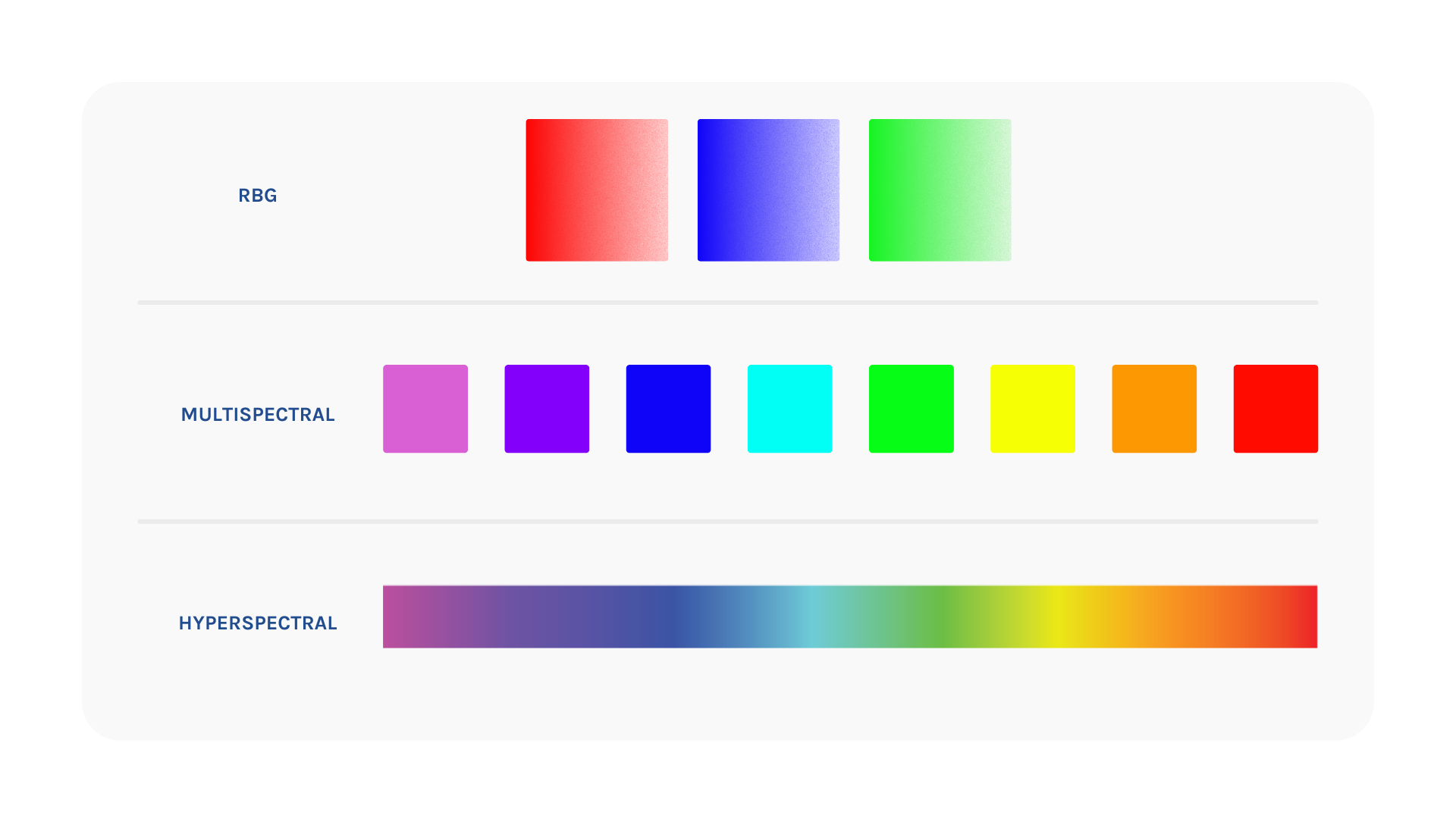
One of the most obvious differences between multispectral and hyperspectral is the number of bands. Multispectral imagery can capture up to 20 bands, whereas hyperspectral can capture hundreds. As a result, the bandwidths of hyperspectral images tend to be narrower than those of multispectral images, resulting in a higher spectral resolution.
Another difference is that multispectral data is captured in a non-continuous sample, leaving gaps within the spectral data. On the other hand, hyperspectral is captured in a continuous sample, as demonstrated in the figure below. Because of these differences, hyperspectral imagery is capable of capturing more detailed spectral imagery, making it a valuable tool for evaluating the specific chemical and physical properties of the Earth that multispectral overlooks. However, with this greater detail captured, the data size of hyperspectral imagery is much larger and more complicated to process.
When To Use Hyperspectral Or Multispectral?
Like all types of earth observation imagery, multispectral and hyperspectral imagery each have their ideal use. If a project requires a high spectral resolution to differentiate between minute features, hyperspectral imagery is a good option. Additionally, hyperspectral data could be fit for a project if the user has adequate resources to store and process the large data set.
On the other hand, if it is possible to get the desired information from a lower spectral resolution, multispectral could be a valid option. This data type is also more beneficial to users that may have tighter budget, storage limitations, and expertise constraints, as multispectral imagery is cheaper and easier to manage and use.
Use Cases
There are many examples, such as those below, of industries applying hyperspectral satellite imagery to extend and improve their processes. With hyperspectral satellites capturing more specific spectral data than multispectral satellites, different band ranges are applicable to specific industries and use cases, providing rich and informative datasets.
Agriculture
The detailed data of hyperspectral imagery has been an informative tool in vegetation analysis and precision farming. For example, hyperspectral imaging has been used to assess the nutrient distribution and photosynthetic efficiency of wheat to identify early stages of crown rot disease. Crown rot is a fungal disease that impacts wheat crops around the world. The biggest challenge associated with existing screening procedures is that there are no visible symptoms during early growth stages. However, the spectral signatures of plants affected by the disease differ from healthy plants. Hyperspectral imagery serves as a non-invasive screening method to detect the disease at early stages based on water and nutrient distribution. This information can then be used to inform essential agriculture decisions.

Credit: Giulia Botan
Mining
Satellite imagery has benefited the mining industry for many years as a tool to effectively monitor all stages of the mine lifecycle. Hyperspectral can be included in these processes as an invaluable tool to detect mineral deposits in prospective sites or address problems during the reclamation process at early stages. Targeting the unique spectral signatures of minerals and compounds reveals concentrations of minerals of interest that can be mapped and measured. The ability to capture spectral data for large areas of interest using satellites is a valuable tool in mineral exploration and mine monitoring, while also reducing labour costs and improving safety.
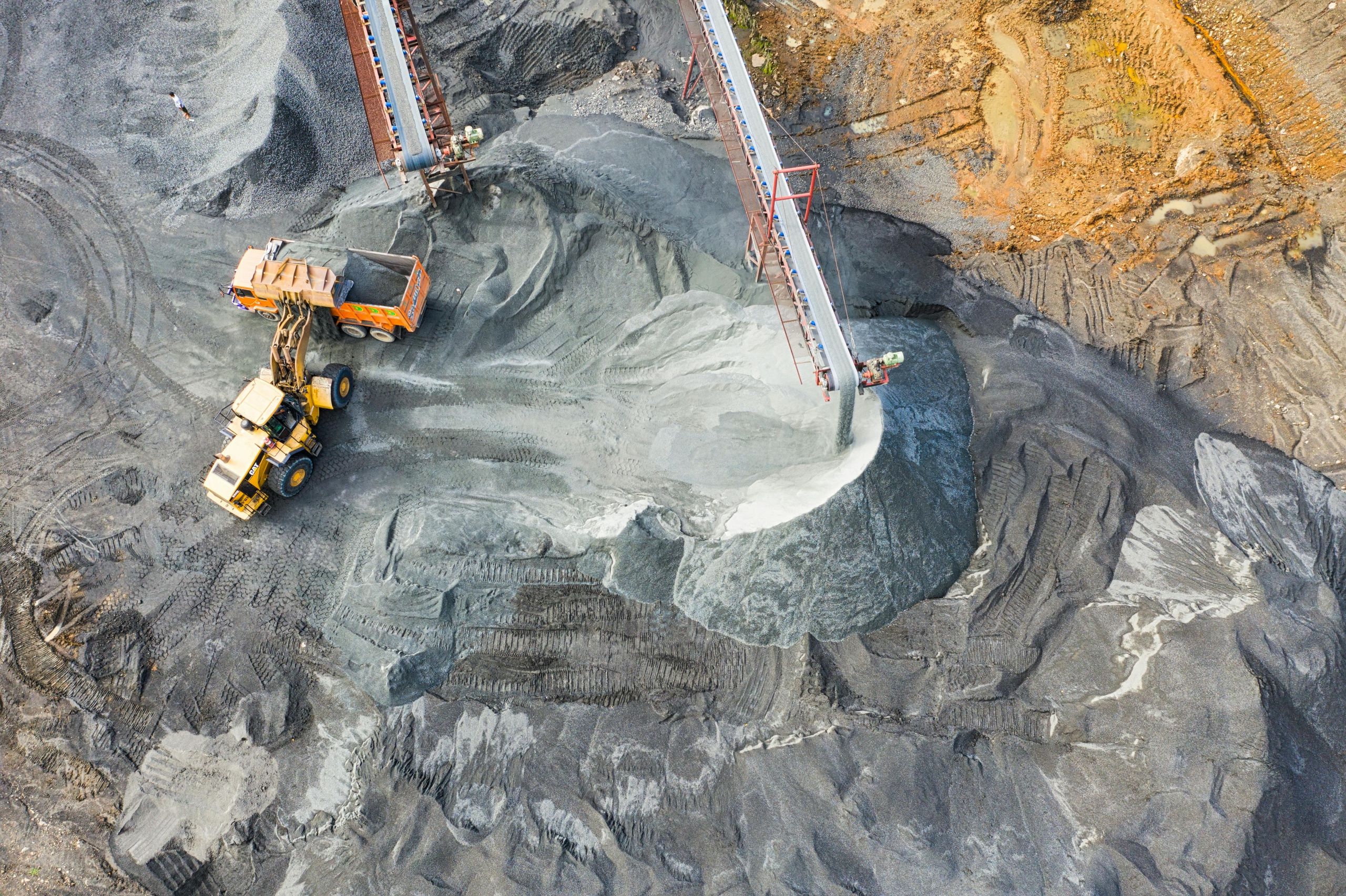
Credit: Tom Fisk
Forestry
Forests are an essential part of local and global ecosystem health. Effective management ensures that these ecosystems and resources thrive for generations to come. Hyperspectral satellite imagery can aid these efforts by identifying specific characteristics of the vegetation and soil, detecting diseases and pests, or assisting with fire mitigation strategies. The unique spectral signature of different species within the forest canopy can be used to identify and map species distribution throughout a forest. Along with this information, spectral data representing the health of the vegetation can alert scientists to areas that pose a high fire risk, due to lack of resources such as water or disease. When used alongside existing systems, industry professionals can use the insight to best manage and protect forests around the world.

Credit: DSD
Both hyperspectral and multispectral satellite imagery are valuable earth observation technologies, providing users with visualisations of “invisible” characteristics. Ultimately, the choice between the two depends on the specific needs and goals of a given project. By understanding the strengths and limitations of each, users can make informed decisions and optimise their insights from data captured.
Curious about predicted commercial trends in hyperspectral imagery?
Check out the white paper Trends and Innovations In Commercial Hyperspectral Technology.
Common Questions
Want to keep up-to-date?
Follow us on social media or sign up to our newsletter to keep up to date with new product releases and case studies.