Driving Climate Action with Effective Geospatial Data Management
The amount of Earth Observation (EO) data available has exponentially increased. With it, critical climate information has become more readily accessible, providing governments and organizations with critical data to find climate solutions. Procuring geospatial data is one thing, but efficiently managing large amounts of that data is another. With recent natural disasters, pollution, and biodiversity loss impacting communities worldwide, efficient management of geospatial data is more important than ever.

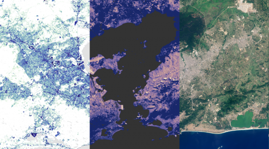
Rio de Janeiro. Captured 25/9/2015 and 26/8/2016 by Landsat 8.
The Challenge
It is no secret that geospatial data has revolutionized climate monitoring and management. However, with the proliferation of growth in the EO industry, managing the decades worth of EO data has shown its own set of challenges. Storage and management, data integration, and regulatory and privacy issues have limited the potential applications of geospatial data.
Management and Storage of climate data
Geospatial data sets and complex climate simulations generate a vast amount of data. The sheer volume of this data poses significant storage challenges. Traditional storage solutions used for scaled data management are inadequate. Complicated management systems can lead to data silos, where critical climate information is fragmented when data is stored separately without sharing or integrating. This results in inefficient workflows, inhibiting the capability to share and distribute climate data when a natural disaster or environmental crisis strikes.
Integration of climate data
Climate geospatial data is often integrated with information from additional sources, such as ground-based sensors or historical datasets, to provide a comprehensive view of changing environmental conditions over space and time. This is essential for making informed decisions about climate management. However, combining data from diverse sources can be complex due to differences in formats, resolutions, and data standards. This results in a time consuming process for teams to clean and standardize their procured data before they are even able to begin analysis. Additionally, there is a specialized skill set required to work with geospatial data that differs from those required of GIS. The skills gap further delays integration of geospatial data into work flows, sacrificing efficiency and therefore impacting response by those further down the pipeline such as farmers or natural resource specialists.
Security and compliance with climate data
Geospatial data is a valuable resource for mission-critical information such as tracking deforestation, surveying for illegal mining operations, or mapping emergency response routes. However, geospatial data is subject to a range of regulations and privacy concerns, which can vary by region, sensor, and application. Compliance with these regulations is critical to avoid legal issues and maintain public trust. When climate data is dispersed, it is difficult to manage protocols, maintain accuracy, safely control access or sharing and ensure compliance.
The Solution
These challenges have opened new opportunities for innovation within the industry to overcome these barriers, and improve climate industry applications. SaaS-based platforms, such as Arlula’s Gestoack, have emerged as a solution. These platforms enable climate professionals to share and integrate historic and new geospatial data libraries on a centralized platform in order to collaborate more effectively and prevent fragmentation. Platforms, such as Geostack, can be equipped with advanced security features designed specifically for satellite imagery protection and compatible with AWS GovCloud to ensure security of your geospatial data. A comprehensive platform addressing each of the above challenges empowers climate professionals from all levels within an organization to make the essential decisions to drive impactful climate action.

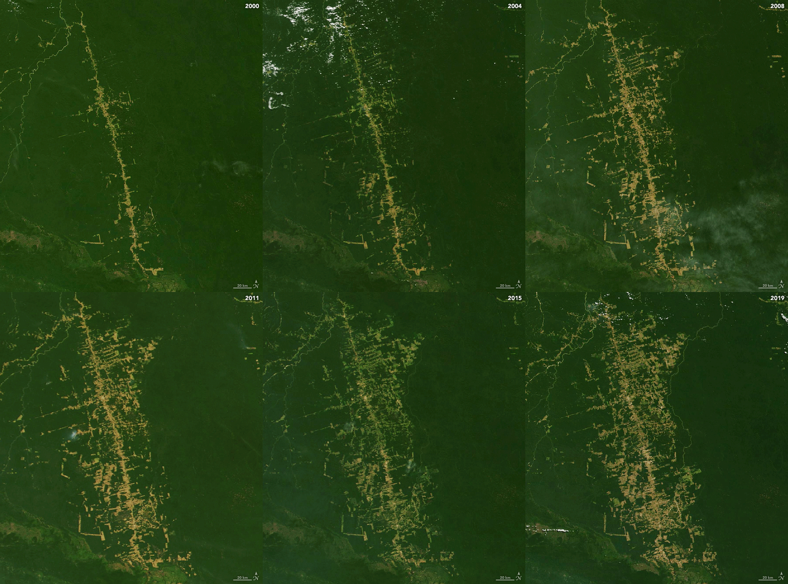
Deforestation of the Amazon from Jun 2000- June 2019. Captured by Landsat.
The Application
Meeting sustainability goals has become a priority to many businesses around the world. Environmental, social and governance standards (ESG) are a company’s commitment to a set of practices to limit social and environmental impact. ESG metrics are increasingly considered by investors and stakeholders to assess the sustainability and performance of companies.
EO data has been an essential tool in monitoring and calculating ESG compliance, particularly the environmental aspect. From carbon footprint mapping to biodiversity assessments, geospatial data has presented valuable information and metrics evaluating environmental impact. As more data is included into sustainability reports, effective management of this data will be necessary to organize, share, and access the relevant data. Climate geospatial data can be procured from many different sensors and time periods. A lack of standardization within the EO industry complicates the procurement and analysis process of this data. Leveraging software that assists in processing these different data types into a standard data product will help to better manage essential climate data. These management tools reduce the time and resources needed to manually process the geospatial data and enable a more consistent analysis.
Additionally, in order to maintain compliance the data sets acquired need to be shared with analysts, reporting organizations, stakeholders, and other regulatory members to ensure accuracy and transparency. A thorough understanding of what data you have and where it is located, streamlines this process, ensuring the right data is available to those who need it. Unfortunately, data silos are a common problem within organizations. Cloud-based data management softwares such as Geostack, eliminate these silos, by providing a centralized sharing and organization solution.
Effective management of climate data also enables better application to rising technologies such as AI and machine learning models. Organized libraries of standardized data allow for models to access and analyse geospatial datasets, providing new insights for resource management, precision crop management, risk assessment and more. Integration with these models further streamlines progress within the climate industry, creating new opportunities to leverage geospatial data to tackle environmental changes.
Conclusion
The growth of the EO industry offers unparalleled opportunities for climate monitoring, response and management. However, the challenges associated with managing, integrating, and securely sharing vast amounts of geospatial data are significant. Platforms like Arlula’s Geostack are crucial in overcoming these challenges. As geospatial data becomes critical in addressing global environmental challenges, effective solutions for EO data management will drive innovation and enable a more proactive climate solution.
Want to keep up-to-date?
Follow us on social media or sign up to our newsletter to keep up to date with new product releases and case studies.


