Detecting Invasive Species with Satellite Imagery
Invasive species pose a significant threat to ecosystems worldwide, with its damage costing over 423 billion every year globally. These non-native plants, animals, and microorganisms can quickly spread and outcompete native species, leading to a loss of biodiversity and disruption of ecological balance. The consequences of invasive species can be devastating, with impacts ranging from reduced crop yields and economic losses to the extinction of native species.
Detecting and controlling invasive species is a critical aspect of conservation efforts. However, traditional methods can be time-consuming, costly, and often ineffective. That’s where satellite imagery and data comes in, offering a game-changing solution in the fight against invasive species.
The Challenges of Detecting and Controlling Invasive Species
The detection and control of invasive species presents numerous challenges. Firstly, invasive species are often difficult to identify, especially in their early stages of establishment. Their visual similarity to native species can make it challenging to differentiate between the two, leading to delayed responses and increased ecological damage, making on the ground efforts particularly challenging.
Secondly, invasive species can rapidly expand, making it difficult for conservationists to keep up with their spread. This can result in a lag time between the initial detection and the implementation of control measures, allowing invasive species to establish themselves and wreak havoc on the ecosystem.
Lastly, the monitoring and control of invasive species require significant resources, including manpower, time, and funding. Traditional surveying methods, such as on-the-ground surveys, can be costly and time-consuming, limiting their effectiveness in large-scale monitoring and control efforts.
Satellite Data and Its Application in Invasive Species Detection
Satellite imagery has revolutionised the way we monitor and manage our planet’s ecosystems. By using satellites, scientists can collect valuable data about our environment, including vegetation health, land cover changes, and even animal movements. Additionally satellite imagery provides a bird’s-eye view of large areas, allowing for efficient and cost-effective monitoring. With a single satellite pass, scientists can gather data on vast expanses of land or water, enabling them to identify and track invasive species across large regions.
Furthermore, satellite tasking enables users to capture data at regular intervals, enhancing one’s monitoring capabilities. The data from these images also provide different multispectral and hyperspectral which allow scientists and researchers to assess areas with heightened precision, with spectral bands having the ability to highlight thermal and vegetative states. This information is crucial in monitoring invasive species, as it helps scientists identify patterns of spread and assess the effectiveness of control measures over time.
Early Detection of Invasive Species Using Satellite Imagery
Early detection is crucial in preventing the establishment and spread of invasive species. Satellite imagery plays a vital role in this process by enabling the identification of invasive species in their early stages.
By analysing satellite images, scientists can detect subtle changes in vegetation or water bodies that indicate the presence of invasive species. For example, invasive plants often exhibit different spectral signatures compared to native vegetation, making them distinguishable on satellite images. Similarly, invasive aquatic species can alter water quality parameters, such as turbidity or chlorophyll levels, which can be detected using satellite remote sensing.
With early detection, conservationists can take immediate action to prevent the further spread of invasive species, whether it’s through targeted removal efforts, the introduction of biological control agents, or the implementation of preventive measures.


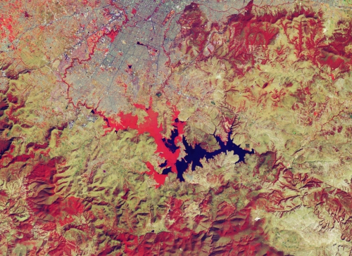
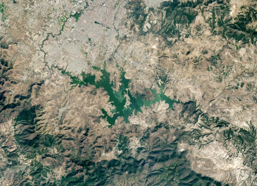
Invasive water hyacinths in Mexico’s Valesquillo reservoir. The false-colour image (left) and the natural-colour image (right) shows the spread of water hyacinths 9 January, 2020. Captured by Landsat 7 and 8.
Tackling One of The World’s Most Invasive Species
When you think of water hyacinths your first thoughts might take you to brand these aquatic plants as beautiful and innocent. Yet these pretty flowers can harbour dangerous intent when not taken care of correctly, with it even being a severe threat to rivers and dams. In fact water hyacinth’s are one the world’s worst aquatic weeds with its trade being illegal in Australia. A study conducted by the Swiss Federal Institute of Technology, found a significant increase in water hyacinths in the past ten years. But how can this aquatic beauty be a menace in many rivers and reservoirs?
Due to its dense mats which spread across water surfaces, water hyacinth’s will often clump together in the water surface, eventually choking the entire water body. This not only severely affects the natural ecosystem but also depletes water bodies of oxygen and increases the amount of mosquitoes. Water hyacinths are also difficult to remove, with the flower easily and rapidly reproducing through waterways of catchments.
One area that has been stricken with this invasive species is Valsequillo reservoir. Located in central Mexico this once clear reservoir has had nearly half of its surface covered with water hyacinths. Through using high-resolution false colour imagery, scientists were able to compare the growth of water hyacinths enhancing monitoring efforts of water bodies to detect the growth of these aquatic plants.
Conclusion
Invasive species play a major risk to our world’s ecosystems with current detection methods and management often slow, expensive, and not always successful. By using satellite imagery and the data it provides, scientists and researchers are able to enhance their ability to monitor areas stricken with invasive species. With different spectral bands having the ability helping to highlight its spread, any trends and overall create control methods to mitigate its damage.
Want Access to High Resolution Satellite Imagery?
With the Arlula’s Geostack, easily obtain decades of high resolution satellite imagery from around the world to help make critical decisions. Search, order and save on high resolution imagery from a range of free and commercial satellites on demand and at scale via our API.
Want to keep up-to-date?
Follow us on social media or sign up to our newsletter to keep up to date with new product releases and case studies.


